|
Kupchino is one of
the oldest names on the map of the
modern city of St. Petersburg. The
‘Northern
Capital’
of Russia has not yet been founded, not
even its founder first Russian Emperor
Peter the Great was born, and the small
village of Kupchinova already existed on
the banks of the River Setuy with its
old and odd title.
Until
the end of the 15th century, this land
belonged to Great Novgorod, and later to
the Grand Principality of Muscovy.
The first mention of
a settlement with the name Kupchinova,
found to date, is in the inventory
revision book of one of the Novgorod
territories, it refers to 1612. The
document mentions five names of the
village householders and the owner of
the village.
According to Stolbovskiy peace treaty
which put an end to the Russian-Swedish
war of 1610-1617, Russia was forced to
cede the territory between the Gulf of
Finland and Ladoga Lake to Sweden. As a
result the area of modern
Kupchino ended up under Swedish control.
Swedes immediately started the census of
everyone and everything on the newfound
territories. First of all, the
population was count to establish a new
tax system. Swedish census takers
reached the territory of the present
Kupchino in 1619. |
|
|
Therefore it was the
second extant documentary evidence of an
unremarkable hamlet near the delta of
the Neva River. Finnish historian Saulo
Kepsu cites Swedish census books, and
mentions some of the early drafts of the
village name: Kuptzinoua (1619, 1634),
Kupsinoua (1622), Kupsonoua (1643).
According to the Swedish census in 1619
the hamlet of Kuptzinoua had four yards,
and four taxable householders lived
there, three of them were Orthodox -
Ifuan Guismin, Pråska
Lefuanteaf, Siman Abrahamof. By 1643 the
hamlet had seven households.
It is quite obvious that the village was
not formed that year, but had existed
earlier. Since we are talking about the
time of the Russian-Swedish War, it is
permissible to assume that in an earlier
period its population was more numerous.
But with the outbreak of hostilities,
and then the Swedish period of rule, the
Orthodox inhabitants left their native
land, fearing oppression, both
administrative and religious, from the
new authorities not without reason. |
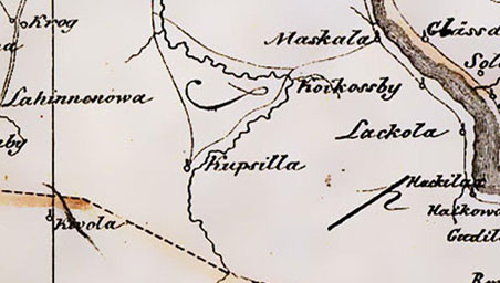
|
Map of
Ingermanland 1676 |
|
|
Considering
the names of the first inhabitants of
the hamlet in the census, we can
conclude that the village was founded in
the middle of the 16th century by
Russian colonists, who at that time were
actively reclaiming the northern lands.
Also we can conclude that the name of
the village is of Slavic origin and
etymologically relates to the Russian
words
‘kupetz’,
‘pokupka’
(‘merchant’,
‘purchase’).
After the change of the state
affiliation the ethnicity of the
population began to change, especially
after the Russian-Swedish war of
1656-1658, when the Orthodox population
of the Neva area were massively deported
to Russia, and the deserted hamlet was
populated with immigrants from the
Swedish Finland. Thus, from the middle
of the 17th century the Finnish names
dominated in the lists of the population. |
|
It
is worth noting that the Slavic name of
Kupchinova has no sense for both the
Swedes and the Finns. This is nothing
more than a mouthful combination of
sounds. Therefore, after 1658 the name
has transformed. Since the end of the
17th century on the Swedish maps hamlet
was called Kupsilla (1676), Cubsilda
(1678), Kupsila (1680), Kupsillda
(1695). The most common name was
Kupsilla, which later became used on
Russian maps, too.
In
1702, during the Great Northern War, the
land previously given to Sweden became a
part of Russia again. In 1711, a number
of villages and heaths along the banks
of the River Setuy, or as it was called
then,
Chernaya (Black)
River were
given to the Alexander Nevsky Monastery,
including mentioned hamlet of Kupsilla.
After the city of St. Petersburg was
founded the hamlet population began to
change again. Slavs returned to replace
the Finnish colonists. And the changes
same as half a century ago started to
happen with the name of the hamlet, but
the opposite way this time. The familiar
and clear name of Kupchino gradually
replaced the title Kupsilla. |
|
|
|
Map of St. Petersburg province 1790 |
|
By
1713, there were five peasant households
and five landless peasants in the
hamlet. In 1714 the hamlet with heath
were given to Tsarevich Alexey Petrovich,
the son of Tsar Peter the Great. After
the death of Alexei Petrovich, in 1718
the hamlet of Kupchino was given back to
Alexander Nevsky Monastery.
Very
little is known about the history of the
village during the period from 1718 to
the end of the 18th century. What was Kupchino like in the 19th century? On
the one hand it was a poky hole of a
place. The hamlet was located away from
busy roads. The only near arterial road
was Kurakina road that connected major
suburban roads: Moscow and Schlisselburg
highways. The hamlet was populated only
by peasants since noble people did not
settle in these places. Before the
beginning of the 20th century there were
no church. The first in Russian Tsarskoselskaya
railway was built in the direct proximity of the hamlet in the end of 1830s, but did not
affect the lifestyle of local residents
as well. Trains passed by without
stopping at the hamlet. On the other
hand, obscurity and isolation made the
hamlet attractive for traders who want
to transport their goods to the capital
of the Russian Empire without going
through customs. There was an active
exchange of goods in the hamlet and, as a
consequence, inns flourished, or, to put
it in modern terms, sales and hotel
business flourished. Kupchino has almost
never been in the bond-hold. Most of its
existence the hamlet was owned by the
State Treasury. And it left an imprint
on the entire rural lifestyle. People
here used to live freely and quite
prosperous. In the description of St.
Petersburg Province dated back to 1838
it is stated that there were 302
residents of both sexes in the
state-owned hamlet of Kupchino. The list
of villages of the same province made by
Regional Committee in 1856 indicated
that there were 40 yards in the hamlet.
Quoting the list of habitations of the
Russian Empire dated back to 1862 there
were 42 yards and 273 residents of both
sexes in the hamlet. In 1905 in the
hamlet there officially lived 342 people
in 62 yards. |
|
|
In 1903 Kupchiners decided to build
their own temple, and in three years
they laid the foundation of the wooden
church. The church was built at the
expenses of the peasants and the famous
St. Petersburg philanthropist, merchant
Ivan Shustrov by engineer Vasiliy Sarandinaki
upon the project of the architect Ivan Sokolov.
The church was hallowed in the name of
St. Gerasimos on November, 1, 1906.
After
the church was built the
hamlet gained the right to be officially
called a village according to the old
Russian tradition.
At the
beginning of the XX century a
village of Romanovo appeared to the
north of Kupchino. It was located
between the modern Belgradskaya and
Sofiyskaya Streets. Meadows and gardens
were significant part of Romanovo. Since
1909, there began an active construction
on the territory. In 1912, the City
Council (as the town hall was called in
Russia) has approved the names of
streets in Romanovo. These streets
mainly were named after the centres of
Russian uyezds (districts). Just in
fifty years these streets will be named
after the capitals of the socialist
countries of the Second World. Shortly
after the October Revolution in 1917,
the village of Romanovo was renamed
Ryleevo to replace the name of the
former Russian emperors with a more
‘revolutionary’
name of the participant of
anti-monarchist coup in Russia in 1825.
In 1919 Ryleevo became a part of the 1st
Municipal District of Petrograd (the
name St. Petersburg had in 1914). After
Petrograd was renamed Leningrad and the
municipalities were reorganized, Ryleevo
became a part of Volodarskiy District.
In 1929, that lands were allocated to
the union of doctors and teachers.
Formed garden co-operative societies
were the first in Leningrad and lasted
until the end of the 1970s. |
|
The
St. Gerasimos church,
picture by Vladimir Isaev |
|
|
In
the mid -1920s, to the north-east of Ryleevo
settlement Nikolayevskiy appeared
near the railway station Farforovskaya.
The name probably came from the
Nikolaevskaya railway that was close to
the place. Workpeople from the nearby
oil refinery Vacuum Oil
(later called Shaumyana Plant) settled
here. In the mid-1930s to the north of
Kupchino, state farm (sovkhoz)
Udarnik
was established. Mainly vegetables and
fruits were grown at the state farm. The
main buildings of the farm were located
on three small streets between the
railway to Vitebsk, and Chernaya River.
Almost in the centre of the state farm
lands there was a small two-storey wooden
building where the office, the
‘Red Corner’,
two primary schools, a medical centre
and two rooms (a youth hostel) were. A
little further there were three wooden
huts where a family hostel was located.
The farm had over 550 acres of land,
2,500 square metres of greenhouses, 60
horses. There were tractors and
vehicles, too. |
|
In
the 1920s at the Kurakina road, now
called the Yuzhnoe (Southern) Highway,
on the place of horse slaughter once
existed here the company for the
manufacturing of bricks was organized.
Bricks were made from clay mined from
quarries on site. In 1936, the
construction of the Number 4 Brick
Factory started here. The brick factory became
operational in 1940. A residential
village was built near the brick
factory. There were one-story and
two-storey wooden barracks in the
village. There was also a medical
centre, dining room, club room. Barracks
were different, some were reserved for
single men, others were reserved for
women, and the rest ere designed for
couples. There were no stoves for
cooking in the barracks, only small
slate-fired stoves for heating in the
rooms. Complementary to the barracks a
large wooden house was built near the
shore of Volkovka (Black) River, and the
families which worked in a brick factory
lived there. Also there were built
beautiful stone buildings of secondary
school and an orphanage. Most of the
villagers had their subsistence farming
with livestock. Around village there
were gardens and yards. The brick
factory grew rapidly. Along one of the
quarries a narrow-gauge railway was
built. A
‘Russian’
railway track with 60-inch gauge was
built from the factory to the train
station Sortirovochnaya.
It exists until now. |
|
|
|
Map of Leningrad region 1924 |
|
After
the Revolution in 1917 villagers of Kupchino were consolidated into the
Thälmann communal farm (kolkhoz), named
after the anti-fascist leader of the
German Communists. The kolkhoz existed
until the Great Patriotic War of
1941-1945. In the pre-war years
residential buildings were located in
the northern part of the village, and
collective farm buildings (the kolkhoz,
the farm club, the school, the farmyard)
were located in the southern part. In
1927, railway station was organized near
the village. Kupchiners have got the
opportunity to use public transport to
get to Leningrad. |
|
|
Meanwhile
Leningrad actively grew. In December
1935 a new master plan for the city was
approved. It did not consider the growth
of the city in the northern direction
because of the proximity of the border.
But the increase of the urban area in
the south-eastern, southern and
south-western directions was planned. Mezhdunarondny (now
- Moskovskiy) Prospect
and Moscow highway (Moskovskoye
Highway) should have become
the central axis of new buildings. The
northern, central and southern arcuate
arterial roads were also outlined there.
A project for extending the
Dzerzhinskogo (now - Gorokhovaya) Street
to the border of the city, and further
beyond existed in the plan. According to
that plan the city limit of Leningrad
lied far to the south of ring railway,
which since the 1920s limited the south
of Kupchino territory. The lands up to
Kuzminka and Slavyanka Rivers should
have become a part of the city, and also Pulkovo were meant to be within the
eastern city limits. Therefore Kupchino
could have become a place directly
adjacent to the new city centre, and in
the process of growth become a city
centre itself. The territory of Kupchino
were lined by a large number of straight
parallel streets, stretching from north
to south, and from east to west
according to the project of perspective
plan of Leningrad in 1935. The
prospective arcuate arterial road
passing through Kupchino and leading to
the Volodarsky Bridge across the Neva
River already built by that time was
outlined there, too. In the early 1940s,
in response to this plan, the city
authorities have started to form a new
business and administrative centre of
Leningrad in the southern part of the
city. To this end, they began
construction of the House of Soviets at
the current Moskovskaya Square. But the
implementation of the whole project was
interrupted by the war. |
|
German map 1941 |
|
|
Since
the beginning of the Great Patriotic War
of 1941-1945 due to the proximity of
the front line Kupchino population was
evacuated in the northern and central
areas of the city blocked by German
troops. Residential buildings were took
to pieces for the construction of
military fortifications and for the
fuel, except three of them that were
left for military purposes. In the first
months of the siege of Leningrad in
special trains residents of the city
were sent from Vitebsk Station to the
area of Kupchino for construction of
fortifications. Nine lines of homeland
defence were created to defend the city
from the south. Two of them were on the
territory of modern Kupchino, one was on
the Kurakina road, the other was on the
line connecting Blagodatnaya Street,
Salova Street and the Farforovskaya
station. In July 1941, 3rd volunteer
Frunze division of the Leningrad
People’s Militia Army was formed from
the residents of the southern part of
the centre of Leningrad. The soldiers
from this division had their baptism of
fire on the Luga defensive line and in
Karelia. Nowadays there is a memorial
sign to fighters of this division on
Prospect Slavy. Also there is a monument to
Georgy
Zhukov, one of the most
famous Soviet generals of the war.
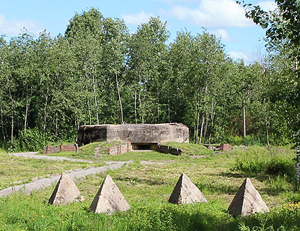
Pillboxes remaining on the territory of Kupchino since then remind about past
heavy war. They were built during the
construction of a defensive line Izhora
in 1943. In 2014 one of these bunkers
was restored and opened as a people’s
museum. |
|
|
|
Museum Pillbox |
|
|
After
the war Kupchino (already as a
settlement) was restored, although it has not
reached the pre-war the size. Thälmann
kolkhoz was not restored. But the state
farm (sovkhoz)
Udarnik
continued functioning and ceased to
exist only in 1960s, with the beginning
of a period of mass housing
construction. Ryleevo and settlement
near Shaumyana plant bombed during the
war were also preserved. The Number 4
Brick Factory was growing, and new
stone houses were actively built in the
settlement near the plant.
In
1948, a new Master Plan of Leningrad was
developed. This time scale of the
designers were more modest and realistic
than in the pre-war years. Kupchino
buildings, according to the project
ended at the city line, which was
limited by the ring railway. When you
look at this project, it is clear that
its developers didn’t
mean to build a
‘concrete jungle’.
On the territory of Kupchino a wide
variety of parks were supposed to be
created, and one of them had to be laid
out on the banks of the Volkovka River.
At that, this part of the river should
have become a part of the southern
bypass channel, planned for the
derivation of transport waterway of the
Neva River. However, this time builders didn’t
get to Kupchino due to lack of funds to
implement the plan. Then plans were
developed in 1955 and in 1959. They also
included the development of the Kupchino
territory, but in those years none of
this plans has been implemented. The
territory of present Kupchino featured
few isolated settlements, horticulture
and numerous state farm fields between
them. |
|
Monument to Georgy Zhukov |
|
|
Everything
has changed dramatically in 1964. A
period of mass housing construction
started. There was nothing left but
memories of the Ryleevo and Shaumyana
villages in which wooden buildings
prevailed. Four brick two-storey
buildings built in 1950s was all that
was left of the central farmstead of the Udarnik
state farm. Many post-war buildings can
be seen nowadays in the former village
near Number 4 Brick Factory. Two pre-war
built stone houses were also preserved,
which were very rare in Kupchino. A
unique complex of wooden buildings of
the 1920s can yet be seen at the railway
station Farforovskaya.
Also pre-war buildings and houses the
first post-war decade can be seen in the
area of Volkovo
Field and along Volkovskiy Prospect and Strelbischenskaya Street.
Kupchino
village also completely disappeared.
Last wooden house for many years
surrounded by five-storey buildings was
demolished in March 1976. But the
ancient name has not died. It was
inherited from the small village by the
enormous urban areas. 1964 is the year
of birth of Kupchino as the urban
district of the
multi-storey residential buildings. That
year the first bearing-wall house was
built. Same year the names were given to
the new highways being built in Kupchino.
Belgradskaya, Budapestskaya,
Bucharestskaya, Prazhskaya, Sofiyskaya Streets ran where once were Ochakovskaya,
Baikalskaya, Siedletskaya, Poznanskaya,
Penzenskaya Streets. Construction began
in the north area. It is the northern
part of Kupchino that is now often
called the Old Kupchino. The fields of
the former state farm were being built
up. It often happened so that just after
harvesting machines were gone
construction equipment immediately came,
and on the place where cabbage grew
shortly before, building piles were
driven. Often residents of first
5-storey houses in Kupchino were beating
a track to their homes among the cabbage
and carrot fields. |
|
|
|
New blocks of flats in Kupchino |
|
Kupchino
has not become a pioneer in mass housing
construction in Leningrad. Much earlier
panel houses were built in the
neighbouring areas. And, of course, Kupchiners benefited from that.
Practically first unsuccessful series of
prefabricated-sections houses were not built in Kupchino. But the
second generation of paneláks were built which by
the standards of that time could be
called quite comfortable. It should be
noted that the task for the builders
given by the government was to settle
the numerous slum quarters and communal
apartments. Therefore, residents of the
central districts of Leningrad became
the first residents of Kupchino
‘Khrushchevkas’
as people call prefabricated houses
built on the initiative of Nikita
Khrushchev, the head of state that days.
Despite the unsettled life, distance
from the centre, and difficulties with
transportation, people gladly moved from
crowded communal apartments into
separate flats. |
|
|
Meanwhile, Kupchino grew to the south.
In place of the 5-storey houses came 9
and 14-storey tower blocks and brick
buildings. In 1970, at the Bucharestskaya
Street
the country’s first self-service store
was opened with its huge trade hall for
12 000 visitors per day. It was named Frunzensky.
Standardly designed widescreen Slava
Cinema
with an auditorium for 1250 people was
built at the corner of the
Bucharestskaya Street and Prospect Slavy.
In 1972 the first Kupchino Metro station
was opened. In 1974, Nevsky overpass
over railway tracks that linked Kupchino and Nevsky
District came into
operation. Territory of south Kupchino
was being built up since 1972. There was
less green and the buildings are higher.
In the east, the housing sector borders
with the Obuhovo
industrial zone. In the south, the
border of the Kupchino district was for
a long time the city limit of the urban
development of Leningrad. On the west
side the area is limited by the railroad
to Vitebsk. The era of mass housing in
Kupchino ended in 1985, when all
supposed for new buildings territories
were reclaimed.
Modern Kupchino is one of the
largest residential areas of St.
Petersburg. Backed by a long history,
the area is one of the newest and most
modern. Kupchino is limited by railway lines:
by the former ring from the north, by
the new ring from the south, by the
railroad to Vitebsk and Moscow from the
east and the west, respectively. Such
isolation, the lack of the roads out of
the city in the recent past and a few
highways that connected Kupchino with
other districts, have generated a lot of
jokes about Kupchino as a poky hole of
place. All these problems are gradually
fading. Kupchiners communication with
the outside world has improved
significantly in recent years: the
construction of new overpasses were
made, a new metro station was open.
There are no large-scale industrial
enterprises in the territory of Kupchino.
The last of these - the brick factory -
moved to a new site in 2013. Cinemas,
which were the centres of culture in the
Soviet period, are now mostly abandoned
and converted into shopping malls.
Although no theatres appeared in the
district in recent years, new shopping
malls have opened up, that have cinemas
onboard. Mobile dolphinarium is
functioning. Area is extremely
attractive for developers, and this does
not always go in district’s
favor. Being once one of the most green
areas of Leningrad, Kupchino is slowly
but constantly becoming a
‘concrete jungle’.
Fewer green areas, parks, lawns remain
since densification actively continues.
After the construction of new houses new
challenges emerge. The first of them is
a problem car parking. The modern houses
are often built with underground parking
garage. But not all residents hurry to
use them immediately as the cost of a
parking lot is sometimes comparable to
the cost of a one room apartment. The
other problem of Kupchino is the traffic
problem, directly connected with cars,
too. The traffic jams lie in wait of
trap for Kupchiners daily in different
places. Every weekday, and sometimes on
the weekends, traffic jams occur all over
the district. It is generally known that
any traffic jam worsen air quality not
only in a single location, but in the
whole area. In other words, the problems
in the district exist, and they need to
be solved. |
|
Monument to the soldiers of the Afghan
war of 1979-1989 |
|
|
|
|
Monument to the
Special Forces
soldiers (Spetsnaz Memorial) |
|
|
There
is no saying that Kupchino somehow
stands out compared to other bedroom
suburbs of St. Petersburg. It is neither
better nor worse. It is just different. Living here has its own pros
and cons. A kupchiner who really knows
the district may guide tourists for
hours, showing them the pre-war wooden
houses and modern high-rise towers,
echoes of war - Pillboxes - and the
monument to the soldiers of the Afghan
war of 1979-1989, the Good Soldier
Schweik (the title character of the
novel of the Czech writer Jaroslav Hašek)
with polished to a shine nose, and
Kupchino tit that is lost among the many
mosaics of
Bucharestskaya Metro station. It has its own legends
and secrets. Kupchiners are mostly
patriots of their
‘small
Motherland’.
Evidence of that is not only
inhabitants interested in the history of
their district, but even the little
things like
Kupchino
T-shirts or stickers on cars, appearing
on the roads on an incredibly regular
basis. Kupchino is an area with a long
history, however, it is very modern and
dynamic. District is praised by many
famous people: artists, writers,
scientists, and politicians. Third
President of the Russian Federation and
the current Prime Minister of the
Russian Federation Dmitry Medvedev was
also born in Kupchino.
‘Kupchino
is the Capital of the World’
is sung in the popular song by Billy
Novick, Billy’s Band founder. Maybe the
world is just concentrated in Kupchino.
Perhaps, on the contrary, the world is
around, and Kupchino is its centre.
Everyone understands this phrase on its
own. But, anyway, Kupchiners like it. |
|
|
|
Bucharestskaya Metro station, underground hall |
|


")
